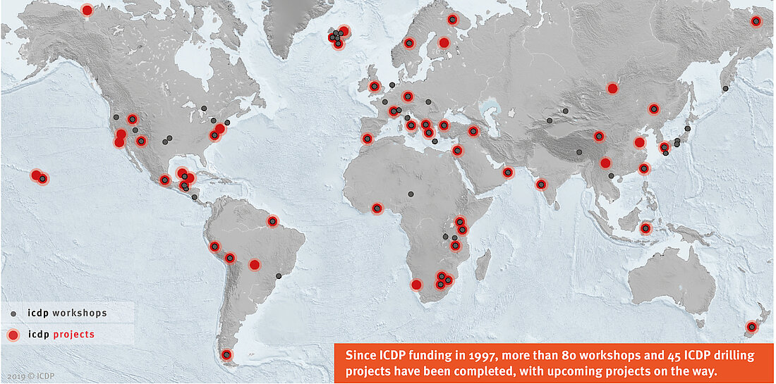
ICDP projects, operating in 2020-2022
Table below lists information about the violet dots in map above.
See also Full Screen Map - List of Recently Approved Projects - All Projects and Workshops
Select more columns, then scroll horizontally to see all columns
| # | Acronym | Project Name | Project Country | Current State | Geologic Age | Proposed | Project Theme | Project Duration | Expedition Id | Project Location | Project Start Date | Proposal ID |
|---|---|---|---|---|---|---|---|---|---|---|---|---|
| 1 | NamCore | The Nam Co Drilling Project, Tibet: A one million year sedimentary record from the third pole | P.R. China | Drilling | Quaternary | 2020 | Environmental Change | 5073 | Nam Co | ICDP-2020/05 | ||
| 2 | BVDP | The Bushveld Complex Drilling Project | South Africa | Drilling | Late Archean | 2019 | Geodynamic Processes | 8 | 5067 | Africa, South Africa, Bushveld | 2020 (Oct) | ICDP-2019/04 |
| 3 | TADP | Trans-Amazon Drilling Project | Brazil | Drilling | Cenozoic | 2017 | Environmental Change | 18 months | 5066 | South America, Brazil, Amazon | 2018 (Nov) | ICDP-2017/01 |
| 4 | TADP | ICDP Workshop: Trans-Amazon Drilling Project | Brazil | Drilling | Cenozoic | 2014 | Environmental Change | South America, Brazil, Andes, Amazonas | ICDP-2014/18 | |||
| 5 | BASE | Barberton Archean Surface Environments, Moodies Group, Barberton Greenstone Belt | South Africa | Moratorium Phase | Archean | 2019 | Geodynamic Processes | 10 months | 5069 | Africa, South Africa, Moodies, Barberton | 2020 (Mar) | ICDP-2019/03 |
| 6 | COSC-2 | Collisional Orogeny in the Scandinavian Caledonides (COSC-2): Drilling the main Caledonian décollement and into the basement of the Fennoscandian Shield | Sweden | Moratorium Phase | Mid-Paleozoic | 2017 | Geodynamic Processes | 5 months | 5054 | Europe, Sweden | 2018 (Apr) | ICDP-2017/04 |
| 7 | DOVE | Drilling Overdeepened Alpine Valleys (DOVE) | Switzerland | Moratorium Phase | Quaternary | 2016 | Geohazards, Environmental Change | 5068 | Europe, Austria, France, Italy, Slovenia, Switzerland, Alpes | 2017 (Jan) | ICDP-2016/04 | |
| 8 | JET | Integrated Understanding of the Early Jurassic Earth System and Timescale | United Kingdom | Moratorium Phase | Triassic, Jurassic | 2015 | Environmental Change | 5065 | Europe, United Kingdom, England, Prees | 2016 (Nov) | ICDP-2015/04 | |
| 9 | SWAIS 2C | Sensitivity of the West Antarctic Ice Sheet to 2 Degrees Celsius | Antarctica | Operational Phase | Neogene - Quaternary | 2021 | Environmental Change | 5072 | ICDP-2021/03 | |||
| 10 | DIVE; IVREA | Drilling the Ivrea-Verbano zonE | Italy | Operational Phase | Permian/Pre-Permian Lower Crust | 2020 | Geohazards | 24 month | 5071 | ICDP-2020/04 | ||
| 11 | STAR | A Strainmeter Array Along the Alto Tiberina Fault System, Central Italy | Italy | Operational Phase | Mid-Paleozoic | 2018 | Geohazards | 3 months | 5070 | Europe, Italy | 2018 (Dec) | ICDP-2018/05 |
| 12 | GRIND | Geological Research through Integrated Neoproterozoic Drilling: The Ediacaran-Cambrian Transition | BZ,CN,Namibia | Operational Phase | Neoproterozoic | 2018 | Geodynamic Processes, Environmental Change | 3 months | 5064 | South America, Brazil, Africa, Namibia, Asia, China | 2018 (Mar) | ICDP-2018/08 |
| 13 | EGER | Drilling the Eger Rift: Magmatic fluids driving the earthquake swarms and the deep biosphere | Czechia | Operational Phase | Cenozoic, Paleozoic | 2016 | Geohazards | 5008 | Europe, Czechia, Western Bohemia, Eger, Eger Rift | 2017 (Aug) | ICDP-2016/05 |
List of some ICDP Projects
(static table, demo)
| Project Name | Expedition-ID | Theme | Continent | Project Phase |
|---|---|---|---|---|
| OODP - Scientific Drilling in the Samail Ophiolite, Sultanate of Oman | 5057 | Sustainable Georesources | Asia | Drilled |
| JET - Integrated Understanding of the Early Jurassic Earth System and Timescale | 5065 | Climate and Ecosystems | Europe | Drilled |
| DeepDust - Probing Continental Climate of the Late Paleozoic Icehouse-Greenhouse Transition | N/A | Climate and Ecosystems | North America, Europe | Workshop |
ICDP Projects, operating in 2020
Alternative Map
Zeigt die Projekte/Lokation aller Projekte, die es auf der Homepage gibt/wozu es Daten gibt. Durch Klick auf den Lokationspunkt kommt man auf die Projektwebsite.
Mouseover – Projektname & Lokation & Time, Farbe der Punkte = Kategorie im Science Plan (Legende),
Interaktive Karte mit Layers, in denen die Punkte anklickbar sind (Web-GIS)
Time, Science Plan Theme, Workshop/Drilling, Year of Drilling, (grau: genehmigte Projekte, die nicht stattfanden?), Land – Land2Sea-Lake

